 By: Timothy Kays
THE VILLAGE REPORTER
“And I wonder, still I wonder…who’ll stop the rain.” ~ John Fogerty
“June 2015 was not only the wettest June on record since 1912, but it was also the wettest month ever,” so said the monthly climatology report from the National Weather Service Forecast Office in North Webster, Indiana (KIWX). I’m not one to speak for other people, but in this case I believe that I’d be hard pressed to find anyone at odds with that declaration…especially considering the last weekend of the month.
Nearly a foot of rain was measured at the KFWA observation station at the Fort Wayne International Airport during June, easily obliterating the previous record for June by over three inches, and breaking the all time wettest monthly record by nearly an inch. This rainfall led to several rounds of moderate to major and significant flooding on area rivers, creeks and streams. Flooding of urban and rural roads was widespread after events on the 15th and 16th, and again on the 26th and 27th. The latter event gives me the shudders in thinking about what it actually was, and what I sincerely hope it is not a portent of. Clarification of this point will be made later.

The average monthly temperature of 69.7 degrees was 0.4 degrees below normal. This ranked as the 56th warmest June on record. The highest temperature was 89 on the tenth and eleventh, and the coolest temperature was 44 on the second. The trepidation mentioned above actually carries forth to the temperature category. Again, clarification will be made later.
Heavy rainfall was indeed the story for June at Fort Wayne as 11.98 inches of precipitation was measured, a whopping 7.82 inches above normal, placing June of 2015 as the wettest June on record since 1912, and easily smashing the old record of 8.55 inches set in 2000. The 11.98 inches was also the greatest precipitation total ever for any month at Fort Wayne, breaking the old record of 11.00 inches set in July 1986. There were 18 days with measurable precipitation. Seven days had a half inch or more; four days had at least one inch of rainfall, and three days…the 13th,15th and 27th, bringing down at least two inches of rain.
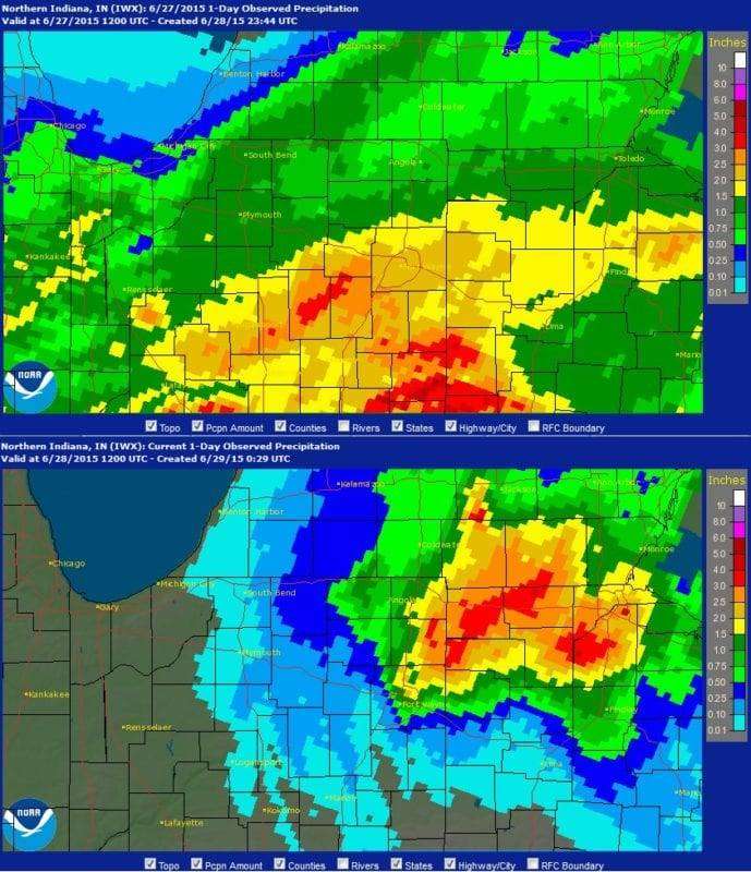
As promised, let us look at the events surrounding the event of June 26-28. As the follow-up report of KIWX stated, “An unseasonably strong low pressure system moved through the Ohio valley June 26th and 27th, bringing moderate to heavy rain to mainly the southern and eastern portions of the forecast area. Strong winds aloft were able to mix down in the rain showers across the area the morning of the 27th. Extremely saturated soils from the excessive rainfall through the month of June made it easy for strong winds of 40-66 mph the morning of the 27th to cause widespread wind damage across the area. Hundreds of trees were uprooted or snapped, and structural damage was reported as trees fell into houses.
Widespread flooding occurred across much of the forecast area, with the exception of far northwestern Indiana and southwestern lower Michigan. Nearly all rivers in the Maumee and Wabash river basins went into flood, with some locations even reaching major flood levels. Evacuations and water rescues took place due to water inundating neighborhoods and from water flowing over roads, especially in Henry County, Ohio.”
Going back to my earlier promised clarifications, we need to examine a meteorological term that one would never think of using during this time of the year…blizzard. Before you consider my last shards of sanity to be a lost to the ages, take a look at the definition of a blizzard, not according to me, but according to the official glossary of the National Weather Service. That definition states that, “A blizzard means that the following conditions are expected to prevail for a period of three hours or longer: Sustained wind or frequent gusts to 35 miles an hour or greater; and considerable falling and/or blowing snow.” With the exception of actual snow, the conditions were met…easily. Since we ARE talking summer here, the snowfall would need to be equated with the stuff that we received in buckets…rain. According to the National Severe Storms Laboratory (NSSL), “On average, thirteen inches of snow equals one inch of rain in the US, although this ratio can vary from two inches for sleet to nearly fifty inches for very dry, powdery snow under certain conditions.”
Okay, now that we have the definitions and the equivalencies all taken care of, let us take a gander at what would have transpired over the last weekend of the month, had the temperatures been low enough to turn the rain to snow. To quote Bob Seger, “Grab a hold of something…hold on tight;” this is a mindblower.

Let us examine four reporting CoCoRaHS rainfall observation stations in the area over three days, June 26-28. First, we will take the totals for each of the three days, then add those numbers to get the event total for the weekend at each location…
Near Pioneer
0.0 – 1.13 – 2.19
3.32” Total
Near Alvordton
0.22 – 1.63 – 2.21
4.06” Total
Near Fayette
0.10 – 1.13 – 3.88
5.11” Total
Near Stryker
0.27 – 1.99 – 3.01
5.27” Total
Now that we have the total weekend rainfall numbers for the three-day event, let us see what kind of snowfall (not sleet) this would have translated into, using the most conservative of the equivalency data provided by the NSSL…
Near Pioneer
3.32” rain = 45.76” snow
Near Alvordton
4.06” rain = 52.78” snow
Near Fayette
5.11” rain = 66.43” snow
Near Stryker
5.27” rain = 68.51” snow
Remember our definition from the National Weather Service? A blizzard means sustained wind or frequent gusts to 35 miles an hour or greater must be occurring (check), there must be considerable falling and/or blowing snow (we’re using rain instead of snow…check), and that those conditions prevail for a period of three hours or longer. This went on for practically three days instead of just three hours, so once again…check.
What does all this blathering bring to the table? What we experienced in our area over the final weekend of the month has been described by some local meteorologists as


‘The Blizzard of June 2015’, and rightly so as it met every criterion set forth in the blizzard definition. The month was colder than normal, and excessively rainy. This is not an unusual pattern, though…and that is what bothers me.
Two years ago, the summer of 2013 was unusually cold and rainy. The cold and rain washed down fruit trees, field and garden blossoms of pollen and nectar. With little or nothing for pollinators to gather, the owners of many local apiaries reported that pollen and nectar, the food that their bees would normally gather and store over the summer months for the upcoming winter, was in seriously short supply. After the record setting severe winter of 2013-14, those same apiary owners opened their hives in the spring to find tens of thousands of bees dead, not just of the cold, but of starvation because their food supplies ran out over the winter. Many colonies were entirely wiped out by the famine induced by unusually heavy rains the summer prior. My greatest concern is that the heavy rains of June will once again put a serious crimp into the food supplies of our most precious agricultural commodity, the common honey bee. They are the prime pollinators of our local fields and orchards. Take them away, and the agricultural picture becomes really ugly…really fast.
It’s not just the bees, though. Is it just me, or are butterflies and bumblebees, two more huge pollinators, seemingly scarce? They may just be bugs to those who don’t understand the reproduction process of the plants that we call food, but in order for those plants to reproduce and create the seeds needed to do so (found in fruits, pea pods, ears of corn, beans, etcetera), they need to spread their pollen around from blossom to blossom. It is those blossoms that, once pollinated, fade away and become the seeds that we harvest and consume.
The Climate Prediction Center is calling for a 40 percent chance of below normal temperatures for July, with a 30 percent chance of above normal precipitation. Trends like this are not particularly great news for the local farmers. With root rot and nitrogen depletion real concerns due to the deluge of June 26-28, more cold rain is going to be a disservice. Consider the fact that the recent cold and damp summers have also been the portent of severe winters in the waiting, I would appreciate some kind of assurance that we aren’t getting set up for another drawn out visit from our old friend, the Polar Vortex.

I don’t even want to think about it!
Timothy Kays can be reached at
tim@thevillagereporter.com