
UPDATE – 3:56 p.m.: Warning Extended Until 5 p.m., Expanded to Include Fulton and Henry Counties
The National Weather Service in Northern Indiana issued a new Severe Thunderstorm Warning at 3:56 p.m. EDT that extends and expands the coverage area. The new warning is in effect until 5 p.m. EDT and now covers eastern Williams County, Fulton County, northern Henry County and northeastern Defiance County in northwest Ohio, along with eastern Hillsdale County in southern Michigan.
At 3:56 p.m., the Weather Service said severe thunderstorms were located along a line extending from eight miles northwest of Addison to six miles northeast of Pioneer to near Paulding, moving east at 45 mph. The primary hazard is now 60-mph wind gusts, with damage expected to roofs, siding and trees.
Locations impacted include Napoleon, Bryan, Wauseon, Archbold, Montpelier, Swanton, Morenci, Delta, West Unity, Pioneer, Stryker, Fayette, Liberty Center, Holiday City, Jerome, Somerset, West Jefferson, Pulaski, Pittsford and Moscow. The warning also includes Interstate 80 in Ohio between mile markers 13 and 48.
The Weather Service is urging residents in the warning area to move to an interior room on the lowest floor of a sturdy building for protection.

Source: NWS Northern Indiana, Severe Thunderstorm Warning issued 3:56 p.m. EDT, May 18, 2026 (in effect until 5 p.m. EDT). Williams County Emergency Notifications Alert 86.
MONTPELIER — The National Weather Service in Northern Indiana issued a Severe Thunderstorm Warning for Williams and Defiance counties at 3:17 p.m. Monday, in effect until 4 p.m. EDT. The warning also covers eastern Steuben County in Indiana and eastern Branch and Hillsdale counties in southern Michigan.
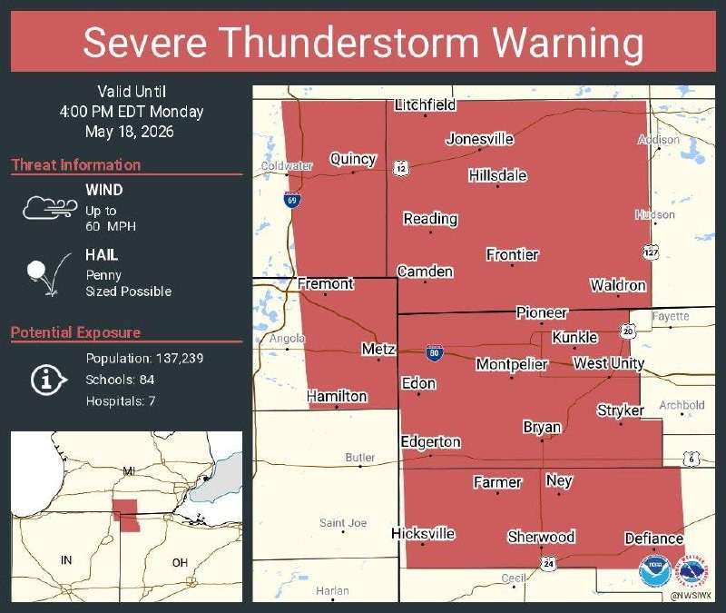
At 3:17 p.m. EDT, radar showed severe thunderstorms along a line extending from seven miles southwest of Homer to near Fremont to near Grabill, moving east at 45 mph. The storms are capable of producing 60-mph wind gusts and penny-size hail. The Weather Service warned of damage to roofs, siding and trees, and said torrential rainfall is occurring and may lead to flash flooding.
Take Cover Now
The Weather Service is urging residents in the warning area to move immediately to an interior room on the lowest floor of a sturdy building, away from windows. Mobile homes and outbuildings do not offer adequate protection — move to a permanent structure before the storms arrive.

Do not drive through flooded roadways. Just six inches of moving water can knock down an adult, and a foot of water can sweep a vehicle off the road.
Communities Impacted
Locations specifically named in the warning include Defiance, Bryan, Montpelier, Hicksville, Edgerton, West Unity, Pioneer, Stryker, Edon, Holiday City and Edgerton in Williams County, along with Coldwater, Hillsdale, Jonesville, Fremont, Quincy, Hamilton, Litchfield, Reading and Long Lake on the Michigan side of the line.
Highway Impacts
- Interstate 69 in Michigan between mile markers 8 and 21
- Interstate 80 in Indiana between mile markers 145 and 156
- Interstate 80 in Ohio between mile markers 0 and 22
Motorists on these stretches should pull off at the next safe exit and wait for the storms to pass. Do not park beneath overpasses, which can create hazards for following traffic and offer no protection from high wind.

Background
Monday’s warning comes inside the broader Severe Thunderstorm Watch No. 220, which remains in effect across northern Indiana, southern Michigan and northwest Ohio until 6 p.m. EDT. Additional warnings are possible through the evening as the cold front continues east.
Updated information will be posted at thevillagereporter.com as the line moves through the area.
Source: NWS Northern Indiana, Severe Thunderstorm Warning issued 3:17 p.m. EDT, May 18, 2026 (in effect until 4 p.m. EDT).